Report your Level - part 2
... From Part 1...
Airspace Level Definition
In the UK, the vertical commencement of airspace is always defined as either an ALTITUDE or a FLIGHT LEVEL.
- Control Zones (CTR’s) extend from ground level up to an ALTITUDE or a FLIGHT LEVEL
- Control Areas (CTA’s) and Terminal Manoeuvring Areas (TMA’s) extend from an ALTITUDE or FLIGHT LEVEL to a higher ALTITUDE or FLIGHT LEVEL
Threat and Error Management
Check equipment prior to getting airborne
There are some checks a pilot should perform prior to even getting airborne. These are:
- Set the Local QNH on the altimeter. The altimeter should show the current (known) airfield elevation +- 60ft (the tolerance for normal general aviation aircraft).
- Set the altimeter to 1013hPa, then set the transponder to a mode that shows the reported Flight Level. The flight Level shown on the transponder must be within 200 feet of the value shown on the altimeter. If outside of these limits, the transponder is out of tolerance. Ensure you set the altimeter pressure setting back to the Local QNH prior to departure.
- For aircraft with more than altimeter, the same pressure reference should be set on both altimeters to cross-check they both indicate the same value (within the required tolerance)
Use the correct pressure setting
When airspace above your location is defined as an altitude, it’s vital that the reference pressure you have on your altimeter is set to the Local QNH. This ensures your pressure reference is set to exactly the same as the reference that is used to determine the vertical limits of the airspace concerned. If you have set a lower reference pressure setting (e.g. QFE or RPS), then your altimeter will be under-reading. In other words. your actual vertical position will be higher than that indicated on the altimeter, and you risk infringing the airspace above you.
Specifically, a pilot must never use the RPS when flying below notified airspace.
The same situation occurs if a pilot has incorrectly set the SPS (1013hPa) instead of a higher QNH when flying beneath notified airspace defined as an altitude.
When inbound to an airfield that resides under notified airspace, you should not change from the QNH to QFE until you are visual with the airfield. If you are operating from that airfield, the only time the QFE should be set (if you really must) is when you are remaining in the circuit pattern. It’s recommended that pilots operate on the QNH at all times, even in the circuit pattern.
Be situationally aware
When airspace above you is defined as a Flight Level, it may well be prudent to either have the second altimeter (if you have one) set to the SPS (1013hPa), or to do a quick calculation to work out the difference between your current altitude (based on the QNH), and the Flight Level that the airspace starts at. The danger lies when the QNH is lower than the SPS. 1hPa equates to approximately 30 feet of altitude, so, for example, if the QNH is 1003, there will be a difference of 10hPa between that and the SPS (1013hPa). When the pressure setting on the altimeter is increased, the indicated altitude will increase. In this case, if we were at an indicated altitude of 3500 feet on 1003, if the pressure setting is changed to 1013, the altimeter will now read 3800 feet (10hPa = 300 feet) with a possible infringement occurring! Consequently, when flying on the QNH below airspace defined as a Flight Level, you must be situationally aware of your vertical position in relation to that airspace!
Moving Map displayed altitudes
Contrary to popular belief, your moving map does not have access to an attached EC device altitude encoder. The altitude detected internally by an attached EC device has no bearing on the altitude displayed on the moving map display for your own aircraft. The altitude shown will always be the GNSS (GPS) derived altitude.
This understanding is incredibly important, especially when the moving map offers a "profile " view of the flight showing the aircraft in relation to notified airspace in the vertical plane. Pilots must never use the profile view alone to determine the aircrafts separation from that airspace – the altimeter must be used!
Traffic!
When your moving map alerts you to conflicting traffic from the data received by an attached EC device, the moving map shows the difference in altitude between your aircraft and the target aircraft using the same pressure reference (SPS) thus enabling separation. Or so you would think.
Note that the altitude encoders within stand-alone EC devices that supply this source SPS data are un-certified. There is no guarantee that the difference in vertical position shown by the moving map display will be based on the same (accurate) pressure reference, and therefore the difference in vertical position may not be accurate. Be especially careful when vertical separation is only a couple of hundred feet; the inaccuracies as a result of un-certified equipment may mean the other aircraft is closer than that. Do not become complacent!
Just to reiterate again, the moving map device only uses the SPS data from the EC device for the traffic vertical position calculation. Moving maps do not use that data for any other part of the display of altitude or height to the pilot.
Beware of the ground!
Some moving maps also show the "accuracy" of the derived GNSS (GPS) altitude, but this figure is not an indication that should not be relied upon. Vertical position information may (in poor conditions) have errors of several hundred feet.
Again, this has implications in utilising moving map vertical position information with regards to airspace. You must not solely reply on the moving map vertical position information. Your primary reference must be the aircraft altimeter with the correct reference pressure set.

All GNSS (GPS) derived vertical positioning will be exacerbated by any loss of SBAS (which goes some way to correcting the vertical inaccuracies), so if your device is not SBAS capable, or SBAS becomes unavailable, errors will be much greater.
Where a moving map device shows GAGL, this should also be treated with caution due to the potential inaccuracy of vertical positioning. Even if your device is SBAS enabled you still need to ensure a good clearance margin.
To Summarise
Please don’t feel that this article is saying moving maps and EC devices are a bad thing. Quite the contrary. Like the CAA, I’d strongly recommend all pilots make use of them. They are great for situational awareness.
In particular though, pilots need to be fully aware of their vertical position, and to make use of the appropriate pressure setting for a given set of circumstances, especially when flying beneath notified airspace.
It is essential that pilots understand the information being presented to them on moving maps and where that data is derived from.
The primary reference for vertical position must be the aircraft altimeter with a correct pressure reference set by the pilot.
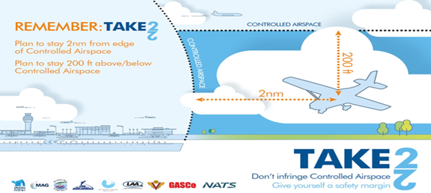
Finally, remember the "Take Two" initiative specified within the UK AIP ENR 1.4 should be undertaken. This states that a pilot should allow either a 2nm lateral separation or a 200 feet vertical buffer from notified airspace. In conditions of turbulence or convective activity, the figure "two" can be increased to three or four to be on the safe side!
Back to Flybyte Articles
|


© Copyright since 2016 Easy PPL Ground School.
All rights reserved worldwide.